
Think or Sink, anthropogenic causes of subsidence in the NL
Description
Predicting the anthropogenic causes of subsidence in the Netherlands and unravel the contributions of deep versus shallow processes.
Problem Context
The Netherlands is subsiding with rates outpacing sea-level rise, as a result of groundwater management, hydrocarbon extraction, and salt mining. This threatens the viability of the country and has great socio-economic consequences, because subsidence results in damage to the built environment, greenhouse gas emissions, and saline water intrusion.
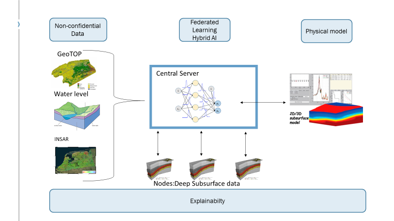
Solution
To allow stakeholders and policy makers to mitigate subsidence, this project will attempt to predict subsidence rates while also unravelling the contributions of different anthropogenic subsidence processes. Data-driven AI algorithms are combined with physical models and physical relations in a hybrid approach to accomplishing this task. The input used for the hybrid models comprises of the datatypes: Earth Observation data (InSAR), water level (Groundwatertools), geological structural model (GeoTOP), gas reservoir production data (Vermilion Energy), GPS and land levelling (Rijkswaterstaat). Explainability is added to the models to understand the contributions of the anthropogenic causes of subsidence. Some challenges that affect this project are combining datasets and overcoming 3D space and time variations, so that the deep learning networks can work properly.
Results
Resources
Contact
- Madelon Molhoek (contact person), Kay Koster, Merijn de Bakker, Thibault Candela, Joanna Esteves Martins, Peter Fokker, Camilla van Wirdum., Consultant Datascience, TNO, e-mail: madelon.molhoek@tno.nl